Ranua
You can help expand this article with text translated from the corresponding article in Finnish. (June 2023) Click [show] for important translation instructions.
|
Ranua | |
|---|---|
Municipality | |
| Ranuan kunta Ranua kommun | |
 Ranua Church | |
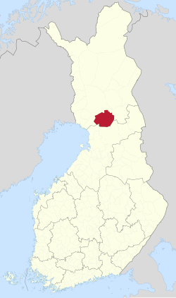
 Location of Ranua in Finland | |
| Coordinates: 65°56′N 026°31′E / 65.933°N 26.517°E | |
| Country | |
| Region | Lapland |
| Sub-region | Rovaniemi |
| Charter | 1917 |
| Government | |
| • Municipal manager | Tuomas Aikkila |
| Area (2018-01-01)[1] | |
| • Total | 3,694.79 km2 (1,426.57 sq mi) |
| • Land | 3,454.17 km2 (1,333.66 sq mi) |
| • Water | 241.09 km2 (93.09 sq mi) |
| • Rank | 14th largest in Finland |
| Population (2024-08-31)[2] | |
| • Total | 3,578 |
| • Rank | 203rd largest in Finland |
| • Density | 1.04/km2 (2.7/sq mi) |
| Population by native language | |
| • Finnish | 98.1% (official) |
| • Swedish | 0.2% |
| • Others | 1.7% |
| Population by age | |
| • 0 to 14 | 17.5% |
| • 15 to 64 | 52.8% |
| • 65 or older | 29.7% |
| Time zone | UTC+02:00 (EET) |
| • Summer (DST) | UTC+03:00 (EEST) |
| Website | www |
Ranua is a municipality of Finland. It is located in the province of Lapland. The municipality has a population of 3,578 (31 August 2024)[2] and covers an area of 3,694.79 square kilometres (1,426.57 sq mi) of which 241.09 km2 (93.09 sq mi) is water.[1] The population density is 1.04 inhabitants per square kilometre (2.7/sq mi).
The municipality is unilingually Finnish.
Geography
[edit]Neighbouring municipalities are Ii, Simo, Tervola, Rovaniemi, Posio and Pudasjärvi.
Villages
[edit]Villages within the municipality of Ranua are inclusive of:
Nature of Ranua
[edit]There are 569 lakes in Ranua.[5] The biggest of them are lake Ranuanjärvi and lake Simojärvi. There are also quite many rapids and natural salmon living in the rapids.
History
[edit]
Ranua was originally the name of a farm established in the 18th century. It gets its name from the lake Ranuanjärvi, which was first mentioned in 1553. Its name is likely of Tavastian origin, as ranu- toponyms are rare and mainly found in Tavastia.[6]
The parish of Ranua was formed from parts of Simo, Pudasjärvi and Rovaniemen maalaiskunta in 1899. The area became a separate municipality in 1917. A part of it was given to the newly formed Posio municipality in 1926. It is the only municipality in Lapland where the dialect is a Northern Ostrobothnian one, albeit with some influence from the Kainuu dialects, which are a subset of Savonian dialects.[7]
Tourism
[edit]Perhaps the most well known attraction is the Ranua Zoo, the northernmost zoo in the world,[8] which has many arctic animals, including the polar bear, which is the mascot of the zoo. Ranua Zoo is the only place where you can see a living polar bear in Finland.
Other notable attractions within the municipality of Ranua are inclusive of the Saukkojärvi Local History and School Museum located in the village of Saukkojärvi, Finland, the Hillamarkkinat, Poro Island and the Church of Ranua.
Sister cities
[edit]Notable people
[edit]- Eero Lohi (born 1927), modern pentathlete
- Lauri Impiö (1929–2006), Lutheran clergyman and politician
- Jouko Kuha (born 1939), long-distance runner
- Taina Impiö (born 1956), cross country skier
- Ilkka Koivula (born 1966), actor
- Kaisa H. Hietala (born 1971), business executive
- Jenna Pirttijärvi (born 1994), ice hockey player
References
[edit]- ^ a b "Area of Finnish Municipalities 1.1.2018" (PDF). National Land Survey of Finland. Retrieved 30 January 2018.
- ^ a b c "Finland's preliminary population figure was 5,625,011 at the end of August 2024". Population structure. Statistics Finland. 24 September 2024. ISSN 1797-5395. Retrieved 25 September 2024.
- ^ "Population according to age (1-year) and sex by area and the regional division of each statistical reference year, 2003–2020". StatFin. Statistics Finland. Retrieved 2 May 2021.
- ^ a b "Luettelo kuntien ja seurakuntien tuloveroprosenteista vuonna 2023". Tax Administration of Finland. 14 November 2022. Retrieved 7 May 2023.
- ^ The number of lakes in Ranua. Jarviwiki.
- ^ "SuomalainenPaikannimikirja e-kirja kuvallinen.pdf" (PDF). kaino.kotus.fi (in Finnish). p. 371. Retrieved 12 October 2022.
- ^ "Savolaismurteiden alue". sokl.uef.fi (in Finnish). Archived from the original on 13 December 2020. Retrieved 12 October 2022.
- ^ Ranua Zoo - Northernmost Zoo in the World - Nordic Adventures – Visit Rovaniemi
External links
[edit] Media related to Ranua at Wikimedia Commons
 Ranua travel guide from Wikivoyage
- Municipality of Ranua – Official website


